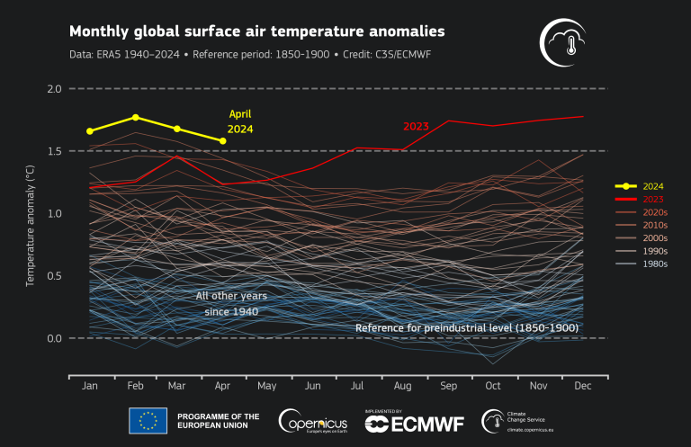
Monthly global surface air temperature anomalies
Credit: C3S


The monthly report highlights the extraordinary duration of record temperatures fuelled by the naturally occurring El Niño event and the additional energy trapped in the atmosphere and ocean by greenhouse gases from human activities. A similar streak happened previously during the strong El Niño event of 2015/2016.
April 2024 had an average surface air temperature of 15.03°C, 0.67°C above the 1991-2020 average for April and 0.14°C above the previous high set in April 2016, according to the ERA5 dataset from Copernicus Climate Change Service (C3S), implemented by the European Centre for Medium-Range Weather Forecasts on behalf of the European Commission.
The month was 1.58°C warmer than an estimate of the April average for 1850-1900, the designated pre-industrial reference period, according to the ERA5 dataset. Monthly breaches of 1.5°C do not mean that the world has failed to achieve the Paris Agreement’s temperature goal, which refers to a long-term temperature increase over decades.
The record temperatures were accompanied by high-impact weather events – including intense heat in many parts of Asia, drought in southern Africa and extreme rainfall in the Arabian peninsula. Persistent heavy rainfall in East Africa and southern Brazil has worsened in the first week of May, leading to devastating and deadly floods.
“The high number of extreme weather and climate events (including record daily and monthly temperatures and rainfall amounts) are more likely in a warmer world,” said WMO climate expert Alvaro Silva.
“The sea surface temperature in several ocean basins, including in the tropical belt, continues to be record high, releasing more heat and moisture to the atmosphere and thus exacerbating conditions,” he said.
The El Niño in the eastern equatorial Pacific continued to weaken towards neutral conditions, but marine air temperatures in general remained at an unusually high level.
The global sea surface temperature averaged for April 2024 over 60°S–60°N was 21.04°C, the highest value on record for the month, marginally below the 21.07°C recorded for March 2024, according to C3S.
WMO uses ERA5 along with five other internationally recognized datasets for its climate monitoring activities and State of the Global Climate reports. The US National Oceanic and Atmospheric Administration, NASA, and Japan Meteorological Agency also issue monthly reports.
Monthly global surface air temperature anomalies
Credit: C3S
There were big temperature differences within Europe. Outside Europe, temperatures were most above average over northern and northeastern North America, Greenland, eastern Asia, northwest Middle East, parts of South America, and most of Africa.
India suffered repeated heatwaves in April and the early part of May, with the India Meteorological Department issuing numerous advisories and warnings to protect people’s health. The highest maximum temperature of 47.2°C had been recorded at Gangetic West Bengal on 30 April. Schools were closed in Bangladesh as a safety precaution against the dangerous heat.
Thailand recorded many new station temperature records – for instance 44.1 ºC at Mueang Phetchabun Phetchabun on 27 April, according to the Thailand Meteorological Department. In Myanmar there were also new temperature records of 48.2°C at Chauk.
Mexico also recorded unusually high temperatures. The station of Gallinas measured 45.8 °C on 2 May – compared to an average May temperature of 34.1 °C (1981-2010 baseline). The heatwave is expected to continue with maximum temperatures greater than 40 °C, according to the national meteorological and hydrological service, CONAGUA.
It was predominantly wetter than average over most of north-western, central and north-eastern Europe. Most of southern Europe were drier than average, according to C3S.
Conditions were wetter than average over central, eastern and southern North America, across Central Asia, the Persian Gulf countries, easternmost Asia, eastern Australia, southern Brazil. Heavy rainfall often led to floods.
Arctic sea ice extent was about 2% below average, a relatively small negative anomaly compared to the previous years, according to C3S.
Antarctic sea ice extent was 9% below average, the 10th lowest extent for April in the satellite data record, continuing a pattern of frequent large negative anomalies observed since 2017.
More Information on 1.5°C: what it means and why it matters | United Nations
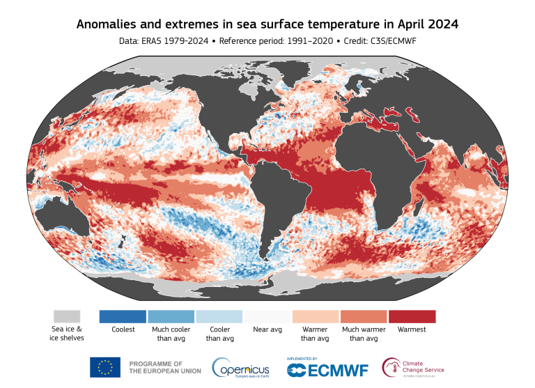
Anomalies and extremes in sea surfaace temperature in April 2024
Credit: C3S
EIN Presswire does not exercise editorial control over third-party content provided, uploaded, published, or distributed by users of EIN Presswire. We are a distributor, not a publisher, of 3rd party content. Such content may contain the views, opinions, statements, offers, and other material of the respective users, suppliers, participants, or authors.